
So we went all the way to Michigan’s Upper Peninsula (UP, pronounced Yoopee) and traveled along the shores of Lake Superior on the US side.

We drove through many remote / sparsely populated places, where we had lame thoughts like “Do you think we are the first French tourists here?”. Even if that’s not true, I think we deserve a medal for visiting the UP in June 2017, the wettest year since 1950 according to a nice Park Ranger we met. We did struggle A LOT camping up there, and that’s probably part of the experience of visiting a wild place like the UP. We got two days and a half of real sunny weather out of our eleven days from the Mackinac Bridge to Duluth, Minnesota, and rain everyday at night, when it was not raining the entire day. There were SO many mosquitoes (more than in the Everglades, Florida!) that we had to stay protected in our van. Each time we were opening the doors of the van, a dozen mosquitoes were coming inside and we had to play the massacre game for one hour before going to sleep. Very quickly we did crave sunshine, a place to dry our stuff and to heal the bug bites. Miserable.
BUT. In the end, we were patient, waited for the sun to do the things we wanted to do, and it was all worth it. The UP will always have a special place in our hearts. Not only because I was able to reuse my K-Way rain jacket from the nineties.

The landscapes we’ve seen were worth all the rain and mosquitos in the world. The cute villages with cute French names —the region was explored by Father Marquette, a French Jesuit missionary in the 16th century— were so welcoming that they largely compensated for the climate. Being there felt a lot like another planet. This place is really wild & mysterious. One day, we followed a road via the information provided by Google Maps, but it ended up being a 30-mile dirt road and we had to turn back after fifteen miles because the road was blocked by a huge water puddle that we did not risk. It’s wiiiiild and that doesn’t happen much, at least not in Europe.
Despite being isolated, the population was rather social and open-minded. We met very surprising “Yoopers”, including a young woman who spoke perfect French in a very small village and had lived in the Reunion, a French island. The UP seems very relaxed about certain things… I didn’t try but it looked like you could almost drink your beer in public, in the street, a feeling that’s pretty rare in this country.
We took some of our best hikes since the beginning of our road trip in March.
Tahquamenon Falls State Park
We started our adventure there by hiking the Tahquamenon Falls State Park. 10 miles round trip following the river between two groups of falls. Never seen so much green before, and the falls…. The falls were stunning.


We saw a huge snapping turtle.

At the end of the trail, it started pouring but we saw the light: there was a brewery next to the parking lot at the Falls (yes, you can go to the Falls by car, call me crazy for hiking it). We drank our reward then we hiked 5 miles back to our campsite.

Pictured Rocks National Lakeshore
We then drove to Lake Superior, stopping in the cute town of Grand Marais. We walked along the shores of the lake, entering Pictured Rocks National Lakeshore. I had never seen a river ending its route inside a lake. Now I have. There are hundreds of small rivers like this, full of minerals giving the lake a reddish color.


 The sky entirely reflects itself in the water of Lake Superior. It’s a scenery that is hard to describe, but for me it was exactly how I feel if I look at a Magritte or Dali painting. Something kind of dreamlike.


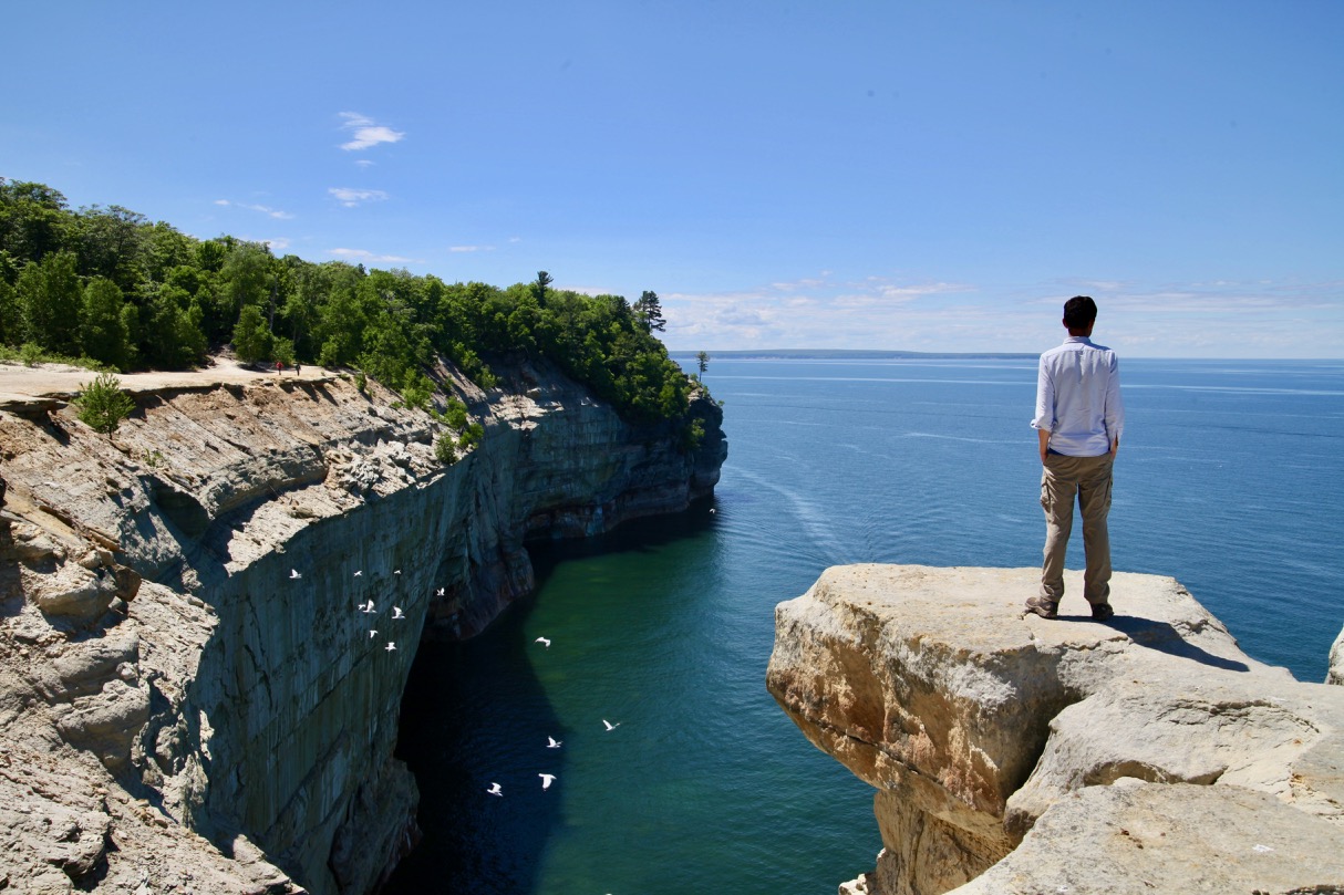
 The real highlight of Pictured Rocks National Lakeshore, and of the entire UP, is a group of cliffs on the shores of Lake Superior. Erosion did a good job at designing the most astonishing coastal landscape I’ve seen in my life.


 You can take an expensive ($45) boat to see the cliffs from the lake… We decided to take the “free-but-hard” way: hiking. We hiked the 12-mile loop (19 km) including at least five miles directly on the cliffs. Each time we were passing a beautiful cliff, there was another one right after with a different shape of feature.


 At some point, we reached a ravine. We were talking to each other from each side of the ravine. Yes, that’s the kind of stuff we find funny. Find Henri in the picture below.
 I’m writing this post from Western Nebraska, so we did escape the Midwest faster than we thought we would, via one night in Wisconsin, and a quick stay in Minnesota were we got more rain and mosquitos. At some point, we drove ten hours straight away from it. We will come back to the Midwest, just not in June 2017.
Note: this blog now exists in French. Oui, Maman!
Beautiful pictures, so refreshing!
Merci Béa. We hope you are doing great. Colorado is nice but we miss Kentucky!!
Already in CO, don’t forget the highest bridge in the world (suspended), Pikes peak, the Garden of the Gods, close to Colorado Springs. I enjoy looking at your pictures. It’s hot now in KY.
We are going back north now, we are going to do the Oregon trail from Mt Rushmore to Oregon via Wyoming and Idaho. A bit unorganized but we’re working at a farm in Oregon in August! (work against housing).